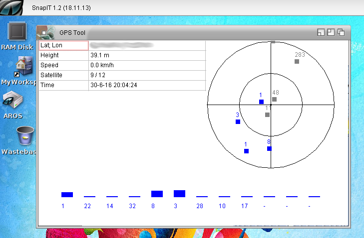
Worked a little bit more with GPS. At Aros-Exec, someone was so kind to test and other GPS with the program seems he also found one which works.
I put all things together and added some more debug output. In principle its still only a tool to learn how to operate GPS devices to build to Mapparium later. But in fact it’s also a nice little tool to play with. The record track function was so easy to implement so it could be a more lightweight tool to record Tracks, instead of the big Mapparium. It even works on Amiga without GFX-card (unlike Mapparium).
It got an own page, on the Mapparium page it would be too messy. But I don’t think they will be much updates on the little program, maybe later I will clean up a bit and put the source to github.
A new Mapparium release bring the image position showing to public including some AREXX commandos for it. But there are more changes. Finally I added a Menu for the Main Window. There are some problems with the menu on MorphOS, and I want to prevent bug announcement about this. I should really again try to find a clue about it. Besides this added overall statistics.
On request I added a nice little feature to Mapparium. It can now extract GPS informations saved in the EXIF of JPG photos. Usually smartphones and better cameras with GPS chips add them to the photos.
Really nice to remember where the photos are taken. a little preview of the image is included, sadly the JPG loading is very slow on MorphOS. I’m not sure whats the reason for this maybe some x86 optimization or general endian problem. So I decided to make the preview with a small preview of the image loaded and call MultiView to show the whole image on request. Mostly the small image is enough to have an idea whats on it. And with MultiView you can inspect in detail. Of course it would be nice to make it configurable later.
Little movie to show how it will work:
The GPS support will have to wait a version more I think, still need a lot of work, and if included track recording and so on should also be implemented, so still a lot of work.
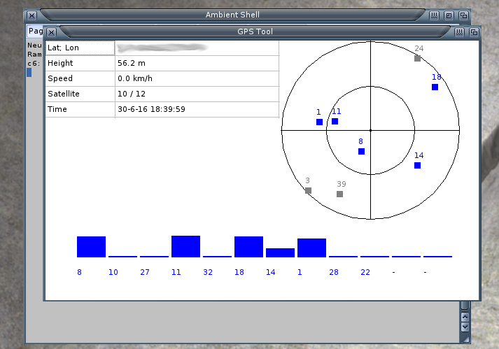
Support for GPS devices will be a nice thing to have in Mapparium. The GPS devices mostly use a protocol name NMEA via serial connection, nowadays mostly via USB2Serial adapter. I own a old Garmin GPS with serial cable and a newer USB GPS device.
The main problem is that my PowerMacG5 Computer does not have a serial interface. But I found out that my USB GPS device can work, by forcing the endpoint 0 it to usbmodem.device, sadly it does not connect by default to this driver, so you first have to force and save it.
So I wrote a little test program to read the serial data from the GPS and parse the NMEA data.
My old Garmin GPS has a nice little interface (device LCD display) to show the position, satellites and other properties. I created a little GUI which look rather the same to visualize the data. And it works really nice for my device.
GPS Tool
Currently it only works for MorphOS and AROS, in principle one could try to forward the serial interface to WinUAE and use it on m68k Amiga.
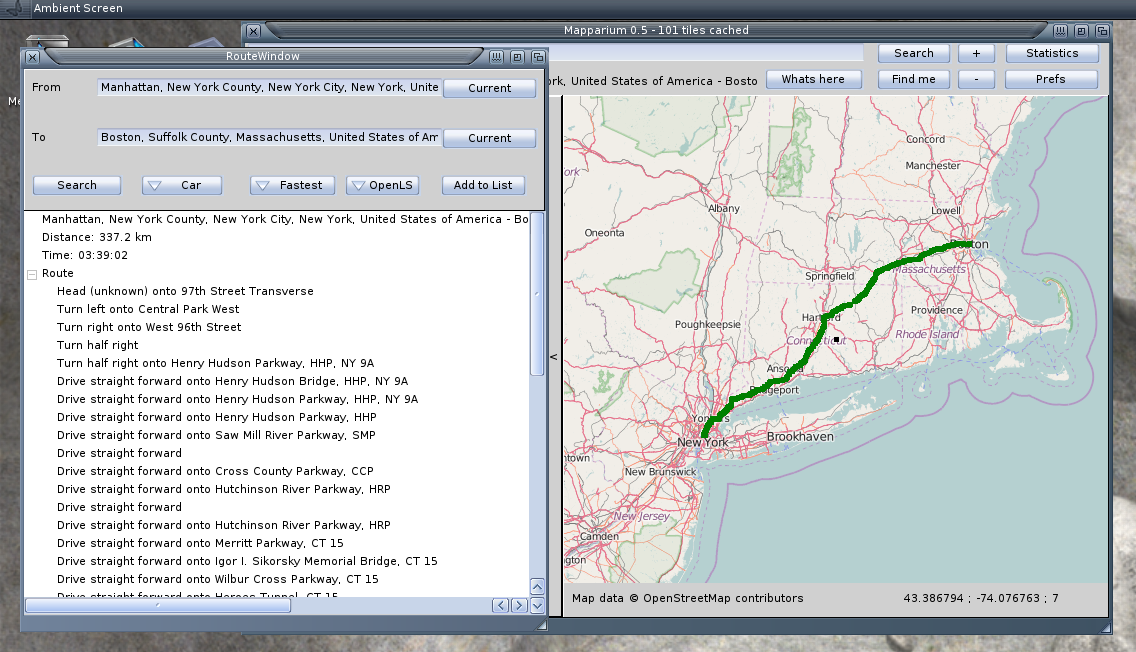
The new Mapparium has some basic route calculation support. I found two usable services, YOUR and OpenLS. Both have positive and negative sides, YOUR is much more reliable but only support the orders as text without coordinates where the direction order is active. OpenLS had on my tests some speed issues, sometimes very slow, even 1 day offline as it seems, but it supplies orders also with position informations.
Changes
FIX: AROS invisible search text
ADD: Routing calculation via YOUR or OpenLS
FIX: better Prefs window
ADD: Save/load routes from GPX
CHG: Open TrackView or RouteView on Show/Edit Button
I got a question, if I will continue with my RSS reader I started a while before. So I searched for it, nice, it’s still on the backup 😛 and it still compiles. The home made HTML parser and print looks still strange, and the whole program is just a start. In fact I did this only to fiddle around with XML/Networking, tried some different RSS feeds all (in the list) seemed to work nicely. But to make a real usable program out of it, I was and I’m still too lazy :-P. And I also don’t think there is a real use for RSS today and every Browser has it already build in. So as an answer I’m not sure if I will ever continue it, Sorry.
I got already some requests for easy route planning inside Mapparium, for me thats not so important, because mostly I just drive without a plan. But it’s funny to play around. In fact I plan both ways of planning, online search „from to“ and manual planing by defining some points. But first make the online search, rather easy with „YOUR“. Sadly the by turn announcements are only supplied as text wit no relations to the route. That means you cannot click onto a announcement and zoom to the map where it should happen. I found another one from the university of Heidelberg, and it has map coordinates for every turn. But today when I tried to implement it’s offline :-O I’m a little bit hesitated to include such a service, if it is this unstable to use. Especially because it’s not just offline, but just lagging some minutes to timeout, which is very annoying, because it looks like the application is crashed. (But just waiting for the answer.)
New Version of Mapparium for all Amiga systems.
Most important changes are, AREXX Port (not available on AROS, due to Zune restriction), Find by IP, Check position, localized search and support for Garmin FIT data. Have fun for me it works already better than my other route inspector programs, I also use it on Linux as my default. I just notice when adding many routes it becomes a litte messy, because the start of every route is the same, maybe I need an option to hide routes from the view.
Changes:
ADD: Clear HD Cache by Button in Prefs to a certain zoom level
ADD: Find current position (by ip)
ADD: Search position by ip (type: ip:x.x.x.x to search)
ADD: Get address for current position
ADD: Zoom in by double mouse click
ADD: AREXX port with commands „goto“ and „addwaypoint“
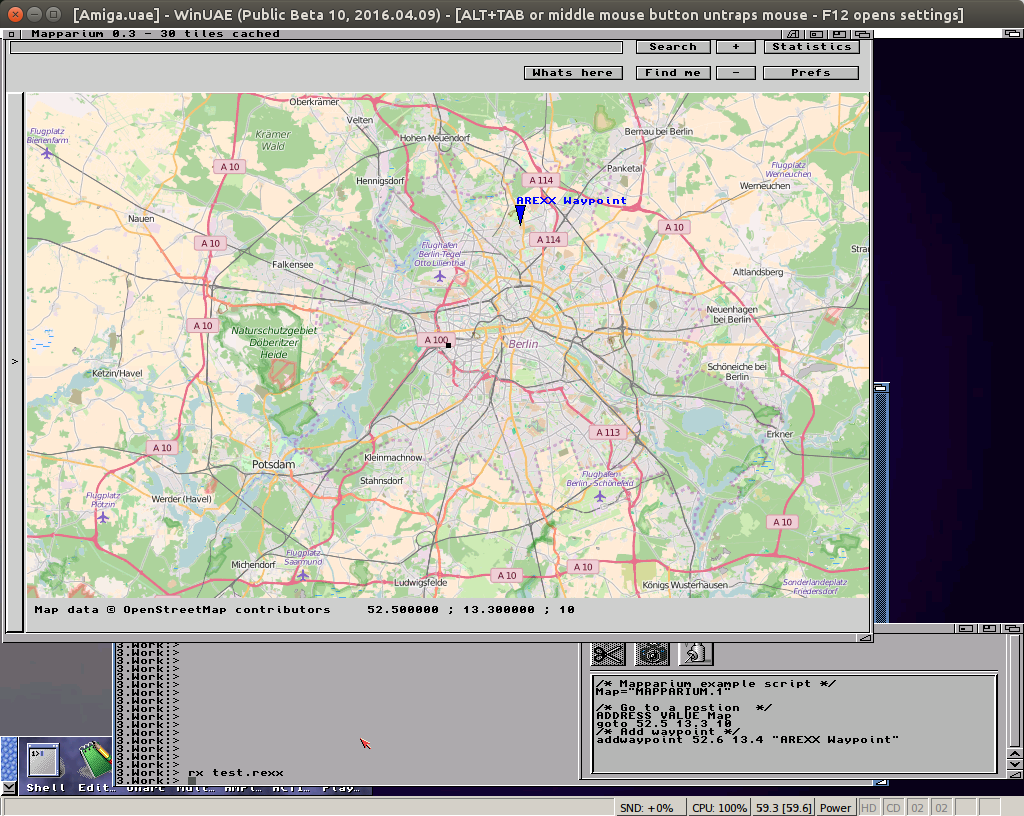
Polluks wrote a little AREXX script to extract positions from JPG exif informations to show on the map, it also create geo: URIs suitable for Mapparium. He also asked me if it would be possible to include AREXX support directly to Mapparium. I always played with the idea to try some AREXX support things, but never had a reason. In principle is rather easy to get a message and return a error value.
I added two simple commands to Mapparium, goto and addwaypoint.
Mapparium with AREXX
At AROS sadly I didn’t get the AREXX (or Regina) to work, thats the reason I implement for Amiga Classic at the moment.
Strange problem appeared with Mapparium on AmigaOS4, all texts are invisible. The funny thing: on my UAE and the OS4 computer at Amiga meeting it was working, difficult to debug. But thanks to some guys at amiga.org I was able to solve it. First I thought it was some Font issue but then I found an informations about color setting in AmigaOS4 and that the given color also contains an alpha value and this was of course always zero for my setting now. MorphOS/AROS/Amiga does not need there a value. And after a failed try (I missed one call) I got a positive feedback from Amiga.org.
Besides this I fixed some little things and implemented Garmin tcx reading (also a xml format but seems only for tracks). Because of this I decided to make a new release for all platforms not only for AmigaOS4 and called it 0.3.
Mapparium 0.3
OpenStreetMap viewer for all Amiga systems.
0.3
FIX: Invisible texts on OS4
FIX: Go offline if internet is down
FIX: Start folder for load/save dialogs
FIX: Filter for dialogs
FIX: Version informations
ADD: Load tracks from Garmin TCX files
ADD: Set size of middle marker
ADD: Support for geo: URIs
ADD: DblClick to lower panel copies middle position to clipboard as geo: URI